The route of IV Zielona Góra Ultramarathon „Nowe Granice” covers mostly forest paths and will be guided along the following areas: Zielona Góra Osiedle Cegielnia, Rybno, Łochowo, Jeleniów, Jarogniewice, Barcikowice/Zatonie, Sucha, Nowy Kisielin, Jany, Stożne, Las Nadodrzański (including a fragment by the river Odra), Wysokie, Przylep, Zielona Góra Osiedle Leśne. The route is a loop, starting and ending in Zielona Góra.
The route can be viewed in map service of our partner traseo.pl.
The route can be also downloaded to the mobile app – Traseo.
The exact GPS path is also available on this site and on the following services:
Movescount (Suunto)
GPSies
Trackprofiler
Garmin Connect
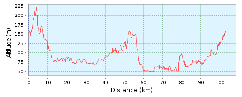
Route profile (+/-570m):
The route will be marked with tapes a few days before the run. There is however a possibility, that some of our marking will be destroyed or removed, so it is recommended to have a GPS receiver with stored route (e.g. an Android phone with navigation app).
